Roger J. Wendell
Defending 3.8 Billion Years of Organic EvolutionSM

Waypoints, GPX Tracks
Grid Squares, and Navigation
Me and my GPS pointing the way on what was then Squaw Mountain...
A simulation of the original design of the GPS space segment
released to the public domain by Wiki user Shushruth
NOTE: LIDAR (Light Detection and Ranging) was put into use many decades after I started hiking and climbing. LIDAR is a more accurate way of measuring the Earth's surface and, as such, has changed what was believed to be the elevation of many mountains and highpoints. As a result, the "prominence" (at least 300 feet above a connecting saddle) of many mountains has changed along with their elevations. A personal example, for me, is Republican Mountain - a previously "unranked" 12er near Silver Plume that I climbed in 2022 after learning that LIDAR had determined it now had 312 feet of prominence. Peak 8, near Breckenridge is another personal example of change brought on by LIDAR. When I originally climbed Peak 8 I believed it to be a 12er, only to learn later that it's actual elevation is 13,005 feet! So, in summary, many of the elevations you see on my pages may not (yet) be accurate - requiring an update someday in the future as time permits!

|
Click Here for the Ten Essentials - Don't leave home without 'em! |
Segal's Law: A man with a watch knows what time it is. A man with two watches is never sure.
I included this adage to my page during the summer of 2023 when I completed a number of tests and experiments with various GPS devices (GPSMap64s, my cellphone, and the cellphones of various friends) and software (CalTopo, AllTrails, GPS Visualizer, Garmin, and others...). What I found was that no two devices (or applications) ever matched as far as the distance and elevation gain that I experienced on a route. In fact, some of them were as much as ten percent different - even on trips less than 10 kilometres in lenghth that had only a few hundred feet of gain. In conclusion, I don't have a clue has to how one can obtain an "exact" reading for any hike or climb. Other than maybe scrutinizing a topographical map. But, even then, the distance between contour lines can distort that data as well. So, who know??!! - Roger J. Wendell, August 2023
Definitions, Descriptions, and Cautionary Notes:
Jolie's waypoint tattoo...A Global Positioning Satellite (GPS) receiver tunes into the microwave signals broadcast by 24 satellites that each orbit the Earth every 12 hours. This "Constellation" of two dozen navigational satellites is controlled by the United States Department of Defense and operated by the U.S. Military (This is an unfortunate situation in that not only is the American military used for suspect purposes but they've also been known to intentionally shut the GPS system down over certain parts of the planet!!). There are six orbital planes (each with four satellites) spaced equally at 60 degrees apart and inclined at abut 55 degrees with respect to the equatorial plane. In plain English this means you can usually count on your receiver "seeing" about five to eight of these satellites at anyone time - depending on where you're located, of course... In August, 1998 I ended up with my first GPS - A Garmin GPS 12XL Personal Navigator. I won the device as a door prize at an amateur radio "swapfest" and it served me well until I lost it in Argentina in 2004... So, in July, 2004 I purchased a Garmin eTrex Vista Personal Navigator. I still don't rely on a GPS completely, for navigation, because I can drop and break it, the batteries die, I can (and have!) lose it, the military can turn it off (as mentioned above), and bad weather and canyon walls can block its signal reception. [Ed. Note: As recently as August 2011 there was still serious concern that solar flares would disrupte the world's GPS devices...]. That being said, a GPS is still a fun little devices to play with so I usually don't leave home without one!

Storing "Waypoints" is one of the features I use most on my GPS. The owner's manual for my GPX 12XL simply defined a waypont as "A specific location saved in the receiver's memory" (bottom of page 3 in the glossary). The waypoints I store are usually the location of a mountain top I've visited, a friend's home, a trailhead, or even the rooftop of the Dalai Lama's Potala Palace in Tibet! Anyway, I'll list my collection of waypoints on this and other pages as time permits. And, as a safety note, I ask that you do not rely on my waypoints for anything - I list 'em here for personal use and cannot verify their accuracy!
[Ed. Note: After the second decade of the second millennium I started using GPS apps on a smart phone but wasn't overly impressed. I think their antennas are lacking (they're internal antennas) so I eventually settled on a Garmin GPSMap 64s - checking the Garmin against maps and other standards I found it to be much more reliable than my cellphone and earlier GPS models. But, that's just my own opinion - please do your own research before relying on any navigational device!]
Andrew Skurka on GPS Units
From his book, The Ultimate Hiker's Gear Guide (Tools & Techniques to Hit the Trail) Second Edition (pp. 132-133)

"Many people seem surprised that I can expertly navigate through the wilderness without relying on a GPS (which stands for 'global positioning system') unit. These devices can:
- Show my exact location, to an accuracy of a few feet;
- Calculate the distance and direction to key landmarks, like my car, a hot fishing hole, or a trail junction;
- Determine how far, how fast, and in which direction I've hiked; and
- Record a track on my route that I can share or use when I get home."
But these functions do not make a GPS a killer app. I can do exactly the same thing with a topo graphic map, altimeter watch, magnetic compass, and pen. Furthermore, a GPS cannot replace map reading skills, especially for off-trail navigation. A GPS can tell me the straight-line distance and direction to a landmark, but it cannot tell me the line of least resistance to get there. That straight line might take me through the thickest brush, into a deep canyon, or across the river at its deepest point."My stance on GPS units has evolved since I wrote the first edition of this guide. I now consider it an ace in my sleeve for when my standard tools reach their limits. First, on a GPS I can store maps and imagery of the areas surrounding my intended route, for which I don't have paper maps. Second, a GPS offers unrivaled speed and certainty."
GPS and Time
The GPS system relies on precise time, both from ground and satellite units, to calculate your exact location in three dimensions. Because of Special Relativity the clocks on the satellites slow down due to their speed. The clocks on the ground slow down even more due to the Earth's gravity well. Therefore, the clocks in oribit must be slowed down, slightly, to match the GPS clocks on Earth. The processor in your gps unit takes all these things into account when it makes its calculations for your speed and elevation here on Earth.
|
|
Click Here for my page on Time... |

|
To calculate elevation, a GPS typically relies on a standard geoid model.
The geoid is the equipotential surface that would coincide with the mean ocean surface of the Earth if the oceans and atmosphere were in equilibrium and at rest relative to the planet's rotation - kind of like a surface of constant gravity if the Earth was entirely ocean. The ellipsoid is an arbitrary reference surface that is an approximation of the Earth's shape, which is basically a sphere slightly "flattened" at the poles. |
"The procedure of geodetic leveling provides a height that is commonly known as a height above mean sea level. In this process, level differences, which express the alignment of a level bubble, are combined with surface gravity readings to obtain final values. Formally, heights from geodetic leveling are known as orthometric heights." "It should come as no surprise that orthometric heights will reflect local variations in gravity as well as changes in topography. The reference surface for orthometric heights is a level surface of the Earth that is closely associated with mean sea level on a global basis. This particular level surface is called the geoid. Orthometric heights are the vertical distance from the geoid to the surface of the Earth. And, by convention, the sign is considered positive as one moves radially outward.""GPS, on the other hand, produces a much different kind of height. Whether one uses point, differential, or differenced carrier phase positioning, one obtains a set of XYZ coordinates that depend upon locations of base stations and satellite positions. These three-dimensional, geometric relationships, in contrast to geodetic leveling, do not depend on local gravity variations. Since XYZ coordinates do not directly express the notion of height, it is necessary to transform them into a different coordinate system. Typically, XYZ are transformed into geodetic latitude, longitude and ellipsoidal height. This transformation is performed using a very simple, two-parameter, model of the Earth: the ellipsoid."
In February, 2009 my friend Jeff was shopping around for a GPS receiver so we both looked into the matter a little more deeply. Again, I'm not an expert in navigation so I strongly recommend you take a class and study the matter before you rely on your GPS for survival. Anyway, a decade ago I was using the term "breadcrumb" track to describe the electronic memory of where my GPS had been tracking my travel. I think now, in the last part of this decade, they're starting to use the term, "tracklog" to describe the same thing. www.gpsinformation.net describes it this way on one of their web pages (they changed their domain name so I don't know if you'll be able to find this exact wording again or not):
"Tracklogs are basically the equivalent of dropping breadcrumbs so that you can retrace your steps. They provide a history of your travels.""A tracklog can be automatically turned into a trackback route to lead you back to your starting point. In addition they can be downloaded to a computer and used to 'playback' your travel over the top of a mapping program so that you can show someone exactly where you went. Since time is also recorded the computer program could also indicate the speed of your travel and compute the length of the trip as recorded in the tracklog. Tracklogs are capable of recording breaks in the log where you moved between fixes or where the unit may have lost a lock. Tracklogs are displayed on the map screen along with visual indications of waypoint locations and your current position."
- Roger J. Wendell
February 2009 - Golden, Colorado
Maidenhead Grid Locator System
and Amateur Radio
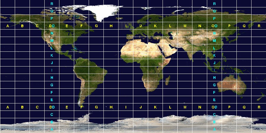
Me, WBØJNRAmateur Radio operators often use the Maidenhead Locator System when providing their QTH (Location) during a communications exchange. The grid locator is a convenient way of expressing location (and aiming antennas!) on VHF, UHF, and the microwave bands. However, "grid squares" are also convenient for QRP (low power transmissions) operators interested in calculating miles-per-watt statistics on the HF bands. "Grid squares" are like rectangles and are a way of dividing up the surface of the Earth. Grid squares are a quick way of describing your general location anywhere on the Earth in a manner that is easy to communicate over the air. The Maidenhead Locator System is named after the town outside of London where it was first conceived, in 1980, at a meeting of European amateur radio operators involved in VHF communications.
A grid square measures 1° latitude by 2° longitude and measures approximately 70 by 100 miles (113 by 161 kilometres) in the continental United States. A grid square is indicated by two letters (the field) and two numbers (the square), as in DM79, the grid square within which Denver area amateur radio operators reside here in Colorado. Grid Squares are further divided into sub squares which are designated by the addition of two letters after the grid square. For example, one of the aforementioned Denver Area amateur radio operators might be located in grid square DM79op - an area called "Smoky Hill" in southeast Aurora, Colorado.
|
|
|
Click Here for the K2DSL Maidenhead Grid Locator Map... |

|
Joe Griffith is a longtime volunteer with the Colorado Mountain Club who served many years as director for their Wilderness Trekking School. Joe, and Trail and Timberline editor Sarah Gorecki, gave me permission to post this article. It appeared in Trail and Timberline issue # 1026 (Spring, 2015), pp. 16-17 |

|
Here are a few Waypoints I've created around our country, and around the world. Again, I ask that you do not rely on my waypoints for anything - I list 'em here for personal use and cannot verify their accuracy! |
Tanzania - January 2003
Marangu Hotel S 03° 17'48.8" E 037° 31'27.9" 4,500 feet 1,372 metres Barranco Hut S 03° 05'43.3" E 037° 19'49.3" 12,950 feet 3,947 metres Barafu Hut S 03° 05'56.4" E 037° 22'41.0" 15,100 feet 4,600 metres Uhuru Peak S 03° 04'36.6" E 037° 21'16.0" 19,340 feet 5,895 metres Mweka Hut S 03° 09'24.6" E 037° 22'01.6" 9,850 feet 3,000 metres
Kenya - January 2003
Old Moses Camp S 00° 02'56.1" E 037° 17'13.5" 11,175 feet 3,400 metres Shipton's Camp S 00° 08'29.1" E 037° 18'53.4" 13,780 feet 4,200 metres Point Lenana S 00° 09'18.2" E 037° 19'05.2" 16,355 feet 4,985 metres Mackinder's Camp S 00° 10'03.1" E 037° 17'36.2" 13,645 feet 4,159metres Met Station S 00° 10'14.1" E 037° 12'49.6" 9,850 feet 3,002 metres
Cuverville Island (Tourist beach)
01-28-2011S 64° 41.085" W 062° 37.843' 56 feet 17 metres Hannah Point, Livingston Island, South Shetland Islands
01-31-2011S 62° 39.243' W 060° 36.661' 37 feet 11 metres Neko Harbor, Andvord Bay, Graham Land
01-28-2011S 64° 50.672' W 062° 31.301' 444 feet 135 metres Neptune's Window, Whaler's Bay, Deception Island
01-31-2011S 64° 50.672' W 062° 31.301' 157 feet 48 metres Port Lockroy (United Kingdom), Goudier Island
01-30-2011S 64° 49.512' W 063° 29.661' 698 feet 213 metres Presidente Gabriel González Videla (Chile)
01-29-2011S 64° 49.438' W 062° 51.433' 260 feet 79 metres
South America:
Buenos Aires, Argentina
Plaza San Martin 01-22-2011S 34° 35.695" W 058° 22.632' 51 feet 15.5 metres Devil's Throat, Iguazú Falls, Argentina 02-05-2011 S 25° 41.734" W 054° 26.240' 582 feet 117 metres Hito Tres Fronteras (Argentina side) - junction of Paraguay, Argentina, and Brazil, where the Iguazú and the Paraná rivers converge 02-05-2011 S 25° 35.682" W 054° 35.444' 524 feet 160 metres Iguazú Falls, Brazil (I took this one while on the metal ramp directly over the falls!) 02-05-2011 S 25° 41.500" W 054° 26.282' 436 feet 133 metres Lima, Peru (Airport)
01-21-2011S 12° 01.513" W 077° 06.463' 185 feet 56 metres Tierra del Fuego National Park, Argentina
01-25-2011S 54° 50.779" W 068° 88.871' 52 feet 16 metres Ushuaia, Argentina (Airport)
(World's southernmost city)
Tierra del Fuego Province 01-25-2011S 54° 50.352" W 068° 18.718' 185 feet 56 metres Ushuaia, Argentina (Port Ushuaia)
(World's southernmost city)
Tierra del Fuego Province 01-25-2011S 54° 48.437" W 068° 18.116' 0 feet 0 metres

|
India:
November/December 2008 |
Amber Fort-Palace, Jaipur N 26° 59.187' E 075° 51.045' 1,558 feet 475 metres Bharat Mata (Mother of India) temple N 25° 19.040' E 082° 59.348' 220 feet 67 metres Jhansi, Uttar Pradesh N 25° 26.925' E 078° 34.145' 807 feet 246 metres Khajuraho (erotic temple art) N 24° 51.157' E 079° 55.375' 687 feet 209 metres Pink City, Jaipur N 26° 55.430' E 075° 49.624' 1,157 feet 353 metres Ranthambhore National Park (entrance) N 26° 01.433' E 076° 27.403' 1,209 feet 369 metres Sarnath Stupa where Buddha preached his first sermon to his disciples N 25° 22.843' E 083° 01.625' 150 feet 46 metres Varanasi on the River Ganges N 25° 18.416' E 083° 00.645' 141 feet 43 metres
 Me at Four Corners... |
Unusual Places: |
4 Corners (Colorado, Arizona, New Mexico, and Utah) N 36° 59.936' W 109° 02.714' 4,831 feet 1,472 metres Dachau (Germany) N 48° 16.111' E 011° 28.121' 1,545 feet 471 metres Darwin Hospital Australia S 12° 21.370' E 130° 52.988' 78 feet 24 metres Potala Palace, Tibet (from the roof!) N 29° 39'28.3" E 091° 07'00.2" 12,000+ feet 3,700+ metres
Europa:
Bregenz, Austria N 47° 30.197' E 009° 44.309' 6,668 feet 1,728 metres Dachau Camp (Germany) N 48° 16.111' E 011° 28.121' 1,545 feet 471 metres Hammersmith, London (intersection of Winslow Road and Fulham Palace Road) N 51° 29.275' W 000° 13.334' faulty reading (-350 feet) faulty reading (-107 metres) Kleine Scheidegg (Switzerland) N 46° 35.115' E 007° 57.677' 6,762 feet 2,061 metres Lechtenstein (one of the entrances) N 47° 13.106' E 009° 34.213' 1,434 feet 437 metres London Heathrow (Intermational Terminal 5) N 51° 31.258' W 000° 28.865' 282 feet 86 metres Mamer, Luxembourg N 49° 37.615' E 006° 01.998' 967 feet 295 metres München, Germany (Downtown) N 48° 08.235' E 011° 34.514' 1,699 feet 518 metres Munich Airport (Terminal 2) N 53° 05.265' E 011° 38.440' 1,346 feet 410 metres Pößnecker Klettersteig - Dolomites (Italy) N 46° 30.893' E 011° 47.458' 9,667 feet 2,947 metres Wolkenstein, Italy (town centre) N 46° 33.282' E 011° 45.643' 5,206 feet 1,587 metres
American States:
Arizona
Click Here for my waypoints in Grand Canyon)
Amitabha Stupa in Sedona N 34° 52.532' W 111° 48.494' 4,619 feet 1,408 metres Biosphere 2 N 32° 34.745' W 110° 51.039' 3,876 feet 1,181 metres Biosphere 2 (top of stairs) N 32° 34.777' W 110° 51.008' 3,903 feet 1,190 metres Crystal Forest, Petrified Forest (April 2014) N 34° 51.855' W 109° 47.440' 5,525 feet 1,684 metres Fort Apache N 33° 47.457' W 109° 59.463' 5,023 feet 1,531 metres Geranimo Pass N 33° 49.422' W 110° 08.662' 5,312 feet 1,619 metres Jasper Forest, Petrified Forest (April 2014) N 34° 53.334' W 109° 48.450' 5,437 feet 1,657 metres Mesa (Main and Sycamore - May 2014) N 33° 24.851' W 111° 52.202' 1,241 feet 378 metres Sedona (Sugar Loaf Trailhead)
June 2011N 34° 52.460' W 111° 47.788' 4,592 feet 1,399.6 metres Organ Pipe Cactus Monument N 31° 57.286' W 112° 48.077' 1,792 feet 546 metres Tombstone (cross streets) N 31° 42.764' W 110° 04.029' 4,472 feet 1,363 metres Winslow (Jackson Brown statue at Second and Kinsley - April 2014) N 35° 01.404' W 110° 41.884' 4,844 feet 1,476 metres
Fredonyer PassCalifronia
Bridgeport - Mono County Courthouse N 38° 15.354' W 119° 13.709' 6,433 feet 1,961 metres Canyondam - Post Office N 40° 10.325' W 121° 04.314' 4,627 feet 1,410 metres Devils Gate Pass N 38° 20.906' W 119° 21.798' 7,519 feet 2,292 metres Donner Pass N 39° 20.485' W 120° 20.394' 7,227 feet 2,202 metres Fredonyer Pass N 40° 21.550' W 120° 52.034' 5,748 feet 1,752 metres I-80 at the Nevada border (March '08) N 39° 28.108' W 120° 00.179' 4,864 feet 1,483 metres Jacumba (Mexican border) N 32° 37.056' W 116° 11.382' 2,795 feet 852 metres Lee Summit Pass N 39° 52.726' W 120° 45.660' 4,439 feet 1,353 metres Mono Lake N 37° 58.681' W 119° 07.721' 6,399 feet 1,951 metres Monterey Cannery Row N 36° 36.964' W 121° 54.024' 20 feet 6 metres Monterey Coast Guard Pier N 36° 36.530' W 121° 53.467' 10 feet 3 metres Monterey Coast Guard Station N 36° 36.546' W 121° 53.864' 50 feet 15 metres Pigeon Point Lighthouse N 37° 10.888' W 122° 23.665' 45 feet 14 metres Pine Ridge Trailhead - Ventana Wilderness N 36° 14.765' W 121° 46.796' 381 feet 116 metres Pt Reyes Lighthouse N 37° 59.743' W 123° 01.390' 270 feet 82 metres Randy's Donuts - 805 West Manchester Boulevard
Iglewood 90301 02-07-2011N 33° 57.710' W 118° 22.218' 116 feet 35 metres Salton Sea - Bombay Beach N 33° 20.854' W 115° 43.780' - 202 feet - 62 metres Sattley (March '08) N 39° 36.939' W 120° 25.573' 4,935 feet 1,504 metres Sierra City (March '08) N 39° 33.932' W 120° 38.153' 4,147 feet 1,264 metres Yuba Pass - Highway 49 (March '08) N 39° 37.043' W 120° 29.388' 6,701 feet 2,042 metres
Independence Pass - 3,686 metresColorado (I also have some waypoints for trailheads, on my hiking page and waypoints for various summits on my 13ers and 14ers pages...)
Alma (Center of town as of August '07) N 39° 17.027' W 106° 03.769' 10,427 feet 3,178 metres Blue Mesa Pass N 38° 23.165' W 107° 26.027' 8,715 feet 2,656 metres Blue Mountain N 40° 15.075' W 108° 51.739' 5,823 feet 1,775 metres Boulder EcoCycle N 40° 01.072' W 105° 12.453' 5,251 feet 1,600 metres Buena Vista - South Main and East Main at River Park N 38° 50.678' W 106° 07.383' 7,965 feet 2,428 metres Buffalo Bill's Grave - Lookout Mountain west of Denver N 39° 43.957' W 105° 14.297' 7,326 feet 2,233 metres Butler Gulch trailhead at the Henderson Mine N 39° 46.269' W 105° 51.288' 10,561 feet 3,219 metres Cameo (at the big Cameo sign next to the Xcel power plant) N 39° 08.958' W 108° 19.021' 4,359 feet 1,328 metres Carbondale N 39° 24.033' W 107° 12.670' 6,181 feet 1,883 metres Cerro Summit Pass N 38° 26.674' W 107° 38.392' 7,988 feet 2,435 metres Chama (Center of town as of August '07) N 37° 09.710' W 105° 22.786' 8,470 feet 2,582 metres Cherry Creek Reservoir (east entrance) N 39° 38.388' W 104° 49.901' 5,744 feet 1,751 metres Coal Bank Pass N 37° 41.941' W 107° 46.641' 10,640 feet 3,243 metres Craig (City Park) N 40° 30.919' W 107° 32.558' 6,185 feet 1,885 metres Crested Butte (Downtown) N 38° 52.238' W 106° 58.934' 8,802 feet 2,683 metres Delta (Intersection of Highways 50 & 92) N 38° 44.714' W 108° 04.243' 4,961 feet 1,512 metres Dolores - Post Office N 37° 28.446' W 108° 29.837' 6,936 feet 2,114 metres Douglas Pass (state highway 139) N 39° 35.844' W 108° 48.312' 8,268 feet 2,520 metres Denver International Airport N 39° 50.893' W 104° 40.352' 5,431 feet 1,655 metres Durango - Train Depot at the Intersection of 5th & Main N 37° 16.149' W 107° 52.939' 6,512 feet 1,984 metres Elk Springs N 40° 21.306' W 108° 26.953' 6,378 feet 1,944 metres Florence N 38° 23.267' W 105° 06.733' 5,263 feet 1,604 metres Four Way - Cielo Vista Ranch N 37° 08.537' W 105° 13.942' 11,078 feet 3,377 metres Fruita Paleontological Area - Trailhead N 39° 09.083' W 108° 45.797' 4,542 feet 1,384 metres Glade Park (Grocery Store) N 38° 59.626' W 108° 44.442' 6,877 feet 2,096 metres Grand Mesa - route 65 N 39° 01.631' W 108° 01.848' 10,839 feet 3,304 metres Grand Junction - 7th & Main historic district N 39° 04.040' W 108° 36.672' 4,620 feet 1,408 metres Grand Junction Regional Airport (Pedestrian entrance into the terminal) N 39° 07.333' W 108° 31.776' 4,858 feet 1,480 metres Green Mountain - Lakewood N 39° 42.059' W 105° 10.664' 6,853 feet 2,089 metres Hayden (Entrance to Routt County Fairgrounds) N 40° 29.462' W 107° 15.573' 6,336 feet 1,931 metres Hoosier Pass N 39° 21.708' W 106° 03.772' 11,539 feet 3,517 metres Hotchkiss N 39° 47.993' W 107° 43.253' 5,351 feet 1,631 metres Independence Pass N 39° 06.497' W 106° 33.876' 12,095 feet 3,686 metres Iron Spring Campground (Montrose County Road 90) N 38° 18.973' W 108° 09.780' 8,960 feet 2,731 metres Kenosha Pass N 39° 24.772' W 105° 45.523' 10,000 feet 3,048 metres KGNU (4700 Walnut) N 40° 01.173' W 105° 14.571' 5,263 feet 1,604 metres Keota (at the intersection of Roanoke Avenue & Tioga Avenue) N 40° 42.219' W 104° 04.417' 4,968 feet 1,514 metres Kremmling N 40° 03.526' W 106° 23.333' 7,364 feet 2,245 metres Lake City N 38° 01.740' W 107° 18.899' 8,625 feet 2,629 metres La Veta Pass N 37° 36.864' W 105° 11.409' 9,413 feet 2,869 metres Leadville N 39° 15.027' W 106° 17.557' 10,152 feet 3,094 metres Lizard Head Pass N 37° 48.677' W 107° 54.509' 10,222 feet 3,116 metres Marble (at the fire station) N 39° 04.218' W 107° 11.445' 7,950 feet 2,423 metres Massadona N 40° 15.096' W 108° 38.370' 5,794 feet 1,766 metres Maybell (Lowell St & Hwy 40 in front of "Betty's Back Porch") N 40° 31.023' W 108° 05.240' 5,920 feet 1,804 metres McClure Pass summit N 39° 07.732' W 107° 17.117' 8,755 feet 2,668 metres Mesa Verde Park Headquarters N 37° 11.053' W 108° 29.317' 6,993 feet 2,131 metres Milner N 40° 29.134' W 107° 01.228' 6,522 feet 1,988 metres Molas Pass N 37° 44.255' W 107° 41.871' 10,910 feet 3,325 metres Monarch Pass N 38° 29.804' W 106° 19.563' 11,312 feet 3,448 metres Montezuma Towne Centre N 39° 34.806' W 105° 52.058' 10,295 feet 3,109 metres Montrose - Main Post Office Monument N 38° 28.740' W 107° 52.608' 5,806 feet 1,69 metres Muddy Pass (U.S. Highway 40) N 40° 22.785' W 106° 34.775' 8,772 feet 2,674 metres Naturita - Town Hall N 38° 12.975' W 108° 33.854' 5,431 feet 1,655 metres No Name (at the I-70 rest stop visitor lookout) N 39° 33.617' W 107° 17.455' 5,905 feet 1,800 metres Norwood - Post Office N 38° 97.852' W 108° 17.397' 7,014 feet 2,137 metres Olathe - Post Office N 38° 36.446' W 107° 58.754' 5,358 feet 1,633 metres Ouray (town centre) N 38° 01.437' W 107° 40.283' 7,775 feet 2,370 metres Paonia (downtown) N 38° 52.119' W 107° 35.976' 5,648 feet 1,721 metres Pearl Pass N 39° 00.328' W 106° 50.290' 11,313 feet 3,448 metres Placerville - Post Office N 38° 01.033' W 108° 03.215' 7,316 feet 2,229 metres Poncha Pass (US 285 runs through it) N 38° 25.325' W 106° 05.279' 9,010 feet 2,746 metres Rabbit Ears Pass (U.S. Highway 40) N 40° 23.005' W 106° 36.708' 9,426 feet 2,873 metres Rampart Range (Flat Rock overlook) N 39° 19.570' W 105° 05.100' 8,230 feet 2,509 metres Rangely (at the police station) N 40° 05.246' W 108° 48.146' 5,224 feet 1,592 metres Redstone (at the town museum) N 39° 10.982' W 107° 14.271' 7,203 feet 2,195 metres Redvale - Post Office N 38° 10.459' W 108° 25.054' 6,483 feet 1,976 metres Rico - Fire Department N 37° 41.407' W 108° 01.890' 8,827 feet 2,690 metres Ridgway Town Hall N 36° 09.157' W 107° 45.308' 7,000 feet 2,134 metres San Luis (Center of town as of August '07) N 37° 11.963' W 105° 25.558' 8,217 feet 2,505 metres Sawpit - Mercantile Store N 37° 59.665' W 108° 00.109' 7,592 feet 2,314 metres Silverton - City Hall N 37° 48.786' W 107° 39.773' 9,318 feet 2,840 metres Slumgullion Pass Summit - Highway 149 N 37° 59.380' W 107° 12.403' 11,530 feet 3,514 metres Somerset (at the Post Office) N 38° 55.578' W 107° 28.213' 6,009 feet 1,831 metres Steamboat Springs (in front of Routt County Courthouse) N 40° 29.077' W 106° 49.912' 6,695 feet 2,041 metres St Johns Mine N 39° 34.235' W 105° 52.896' 10,839 feet 3,304 metres Sunbeam (Entrance to Nielson's Keyhole Ranches) N 40° 33.019' W 108° 12.031' 5,889 feet 1,795 metres Telluride - San Miguel County Seat N 37° 56.267' W 107° 48.775' 8,777 feet 2,675 metres Trout Creek Pass (US 285 runs through it) N 38° 54.600' W 105° 58.528' 9,346 feet 2,848 metres Vail Pass N 39° 32.513' W 106° 13.047' 10,603 feet 3,232 metres Vallecito Dam (halfway across) N 37° 22.784' W 107° 34.515' 7,641 feet 2,329 metres Villa Grove (US 285 runs through it) N 38° 14.919' W 105° 56.945' 7,986 feet 2,434 metres Vicksburg (Museum parking) N 38° 59.903' W 106° 22.555' 9,649 feet 2,941 metres Westcliffe N 38° 08.016' W 105° 27.829' 7,888 feet 2,404 metres Winfield N 39° 59.114' W 106° 26.469' 10,245 feet 3,123 metres Wolf Creek Pass N 37° 28.978' W 106° 48.134' 10,860 feet 3,310 metres Zenobia Peak (Dinosaur National Monument) N 40° 36.435' W 108° 52.2004' 9,006 feet 2,745 metres

Click Here for the Longitude and Lattitude of Colorado's 14ers...
Florida (November 2011)
Everglade National Park Office (on the front steps) - town of Everglades N 25° 50.729' W 081° 23.201' 16 feet 4.8 metres Southern Most Point - Key West N 24° 32.790' W 081° 47.850' 8 feet 2.4 metres Roser Park Historic District - At the 8th St S & 8th Ave S entrance, St. Petersburg N 27° 45.736' W 082° 38.753' 44 feet 13 metres Toon Lagoon - Islands of Adventure, Universal Studios, Orlando N 28° 28.129' W 081° 28.260' 98 feet 34 metres US 1 Mile Marker 0 - Key West N 24° 33.316' W 081° 48.241' 16 feet 4.8 metres
Hawai'i (February 2007)
Diamond Head Summit - O'ahu N 21° 15.584' W 157° 48.706' 746 feet 227 metres Haleakalā Summit - Māui N 20° 42.588' W 156° 15.164' 10,023 feet 3,055 metres Kipahulu - Near Hana, Māui N 20° 39.723' W 156° 02.743' 403 feet 123 metres Lān'i City, Lān'i N 20° 49.066' W 156° 55.104' 1,580 feet 482 metres Manele Harbor, Lān'i N 20° 44.528' W 156° 53.293' 10 feet 3 metres Mauana Kea, Hawai'i Island N 19° 49.371' W 155° 28.152' 13,796 feet 4,205 metres Pipeline - Northshore O'ahu N 21° 39.976' W 158° 03.109' 56 feet 17 metres South Point Complex, Ka Lae, Hawai'i Island N 18° 54.642' W 155° 40.845' 0 feet 0 metres Note: South Point Complex, on Hawai'i Island, is the southern most point in the United States.
Tami and I marked this waypoint in February, 2007 while walking around the pounding surf on what
rocks were exposed at that time between waves. I suspect the actual point is where the Coast Guard
light beacon is positioned, just a dozen or two metres north of where we took our reading...
Maryland
USPS Bolger Center - Potomac N 39° 01.267' W 077° 11.245' 334 feet 102 metres
Baker Archeological Site (AKA Baker Village)
Open plaza in front of the "Big House" (site # 8)
08-04-2011N 39° 02.246' W 114° 07.345' 5,298 feet 1,615 metres Baker Post Office 89311 08-04-2011
near intersection highways 487 & 488N 39° 00.738' W 114° 07.378' 5,319 feet 1,621 metres Blackrock Summit Highway 6
08-02-2011N 38° 30.250' W 115° 54.836' 6,257 feet 1,907 metres Bob Scott Summit - Highway 50 (Nov '07) N 39° 27.426' W 116° 59.780' 7,267 feet 2,215 metres Connors Pass Highway 6
08-02-2011N 39° 02.330' W 114° 38.834' 7,722 feet 2,353 metres Currant Summit Highway 6
08-02-2011N 39° 49.108' W 115° 17.032' 6,999 feet 2,133 metres I-80 at the California border (March '08) N 39° 28.108' W 120° 00.179' 4,864 feet 1,483 metres Murry Pass Highway 6
08-02-2011N 39° 12.884' W 114° 58.353' 7,316 feet 2,230 metres Pahrump - Intersection of 160 & 372 (Pahrump Valley Blvd, June 2011) N 36° 12.521' W 115° 50.053' 2,643 feet 805.6 metres Sacramento Pass Highway 6 & 50
08-02-2011N 39° 08.584' W 114° 20.189' 7,154 feet 2,180 metres Sand Springs Pass - Highway 116 (March '08) N 39° 16.417' W 118° 21.068' 4,644 feet 1,415 metres Saulsbury Summit Highway 6
08-02-2011N 38° 07.818' W 116° 44.747' 6,522 feet 1,988 metres Shurz - Highway 95 (Feb '08) N 38° 57.011' W 118° 48.623' 4,123 feet 1,257 metres Stillwater (March '08) N 39° 31.301' W 118° 32.796' 3,919 feet 1,195 metres Tonopah Post Office 89049 (Highway 6 & 95)
Main Street & Bryan Avenue
08-02-2011N 38° 07.818' W 116° 44.747' 6,522 feet 1,988 metres Warm Springs Summit Highway 6
08-02-2011N 38° 09.982' W 116° 26.677' 6,293 feet 1,918 metres
New Mexico
Laguna Pueblo (intersection of Sparrow Hawk Road, Mesita Road, and old Route 66 Road - April 2014) N 35° 00.836' W 107° 19.187' 5,670 feet 1,728 metres
North Dakota (May 2009)
White Butte (state high point) N 46° 23.223' W 103° 18.154' 3,506 feet 1,068 metres
Oklahoma (January 2007)
USPS NCED - Norman
(South side center/lake by Highway 9)N 35° 11.451' W 097° 23.982' 1,226 feet 374 metres
South Dakota (May 2009)
Harney Peak (state high point) N 43° 51.957' W 103° 31.869' 7,244 feet 2,208 metres
Texas (May 2006)
Mayan Ranch near Bandera N 29° 43.158' W 099° 05.375' 1,325 feet 404 metres
Utah (November 2007 and May 2011))
Landscape Arch - Arches National Park N 38° 47.471' W 109° 36.417' 5,263 feet 1,604 metres Sego Canyon Petroglyphs N 39° 01.140' W 109° 42.584' 5,456 feet 1,654 metres Unnamed Summit "6280" Highway 6 & 50
(22.5 miles east of the Neavada border)N 39° 04.439' W 113° 38.356' 6,280 feet 1,914 metres
Washington State (June 29, 2008)
Mt. Baker N 48° 46.601' W 121° 48.875' 10,778 feet 3,285 metres
Wyoming
Pindedale (in front of the Post Office at 413 Pine Street), Sublette County N 42° 52.003' W 109° 51.942' 7, 175 feet 2,187 metres
Links:
- 12ers
- 13ers
- 14ers
- Aconcagua (Argentina)
- Africa (Eastern) - Kenya, Tanzania, and my Kilimanjaro climb
- Africa (Southern) - Our trip through Botswana, South Africa, Zambia, Zimbabwe
- AIARE - The American Institute for Avalanche Research and Education
- Alpine Resuce Team - Evergreen, Colorado
- AllTrails
- Amazonia and Ecuador
- American Avalanche Association
- AMSAT Grid Square Conversion
- Antarctica
- Argentina and Brazil
- Arizona
- APRS - Automatic Packet Reporting System
- ARRL explains Maidenhead Grid Squares
- Australia Main Page
- Australia Two Page
- Backcountry Skiing
- Barefoot
- Bear Safety
- Bolivia
- Breadcrumbs - Simple GPS Track Management
- CalTopo - USGS Topo Maps
- China
- Climbing
- Colorado
- Colorado Avalanche Information Center
- CMC Colorado Mountain Club
- Colorado Trail
- CoTrex - Colorado Trail Explorer
- Ecuador
- FindU - Linking local RF networks
- Gear - Stuff for the Backcountry...
- GeoPlaner
- GPS Information Resource
- GPS Visualizer: Do-It-Yourself Mapping
- GPX Studio - the online GPX file editor
- Grand Canyon
- Grid Locator
- Highpoints
- Hiking
- India
- Ireland
- Japan
- Leave No Trace - Center for Outdoor Ethics
- Lightning Safety
- Mexico
- MyTopo - Free USGS topos
- Nevada
- New Zealand
- Open Street Map - A community of mappers!
- Other Peaks that I have climbed
- QGIS - A Free and Open Source Geographic Information System
- Russia
- Silk Road
- Skiing - in the backcountry!
- Snow Caves
- Summitpost.org
- Survival in the backcountry
- Ten Essentials - Don't leave home without 'em!
- Tibet
- Track Report - An online tool for GPX file analysis
- Trail Journals
- Travel
- Travel Two
- United Kingdom - England
- United Kingdom - Wales and Scotland
- Walking Softly in the backcountry
Warning! Climbing, mountaineering, and backcountry skiing are dangerous and can seriously injure or kill you. By further exploring this web site you acknowledge that the information presented here may be out of date or incorrect, and you agree not to hold the author responsible for any damages, injuries, or death arising from any use of this resource. Please thoroughly investigate any mountain before attempting to climb it, and do not substitute this web site for experience, training, and recognizing your limitations!
Back to Roger J. Wendell's Home Page...

Abbey | About | Blog | Contacting Me | Copyright | Disclaimer | Donate | Guest Book | Home | Links | Site Index | Solutions | Terms, Conditions and Fair Use | What's Changed or New?
Copyright © 1955 -


